Current Ag Issues

203 Road

Forest Road 203

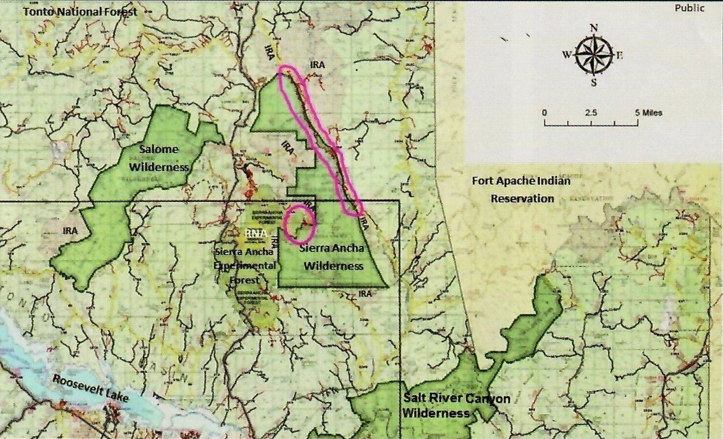
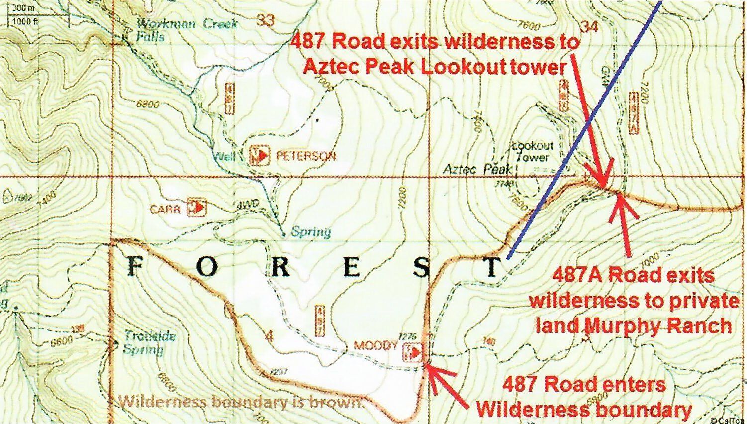
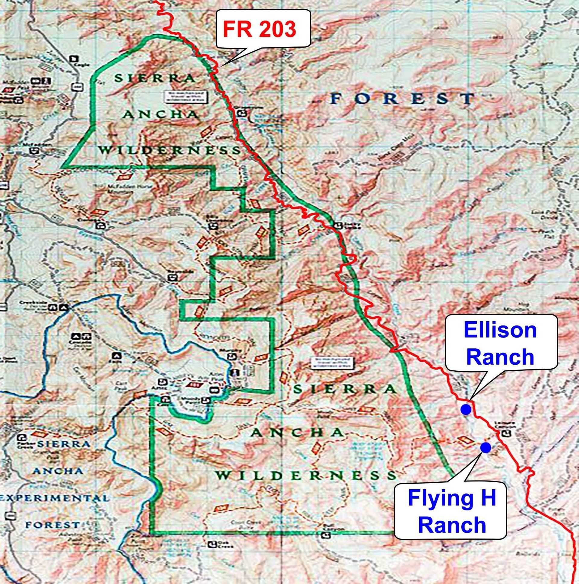
Forest Road 203/Cherry Creek Road: A 10.05-mile section of Forest Road 203 is slated to be decommissioned through the current Travel Management Planning (TMP) process because the road meanders in and out of the Sierra Ancha Wilderness (SAW) within this section. Also, when the SAW was designated in 1964, there was no language specifying that Forest Road 203 remain a motorized access system road. However, it has been managed as an open motorized road since at least the 1950s, with continuous use since that time. Additionally, the road was improved and maintained in the 1950s by the Atomic Energy Commission. In addition to the 203, a small section of Forest Road 487/Workman Creek Road is slated for closure to the general public.


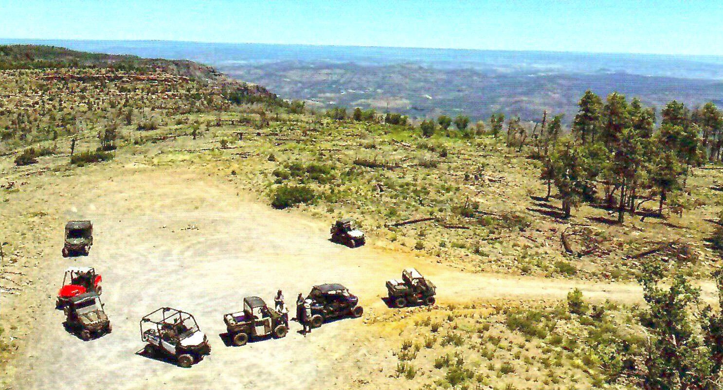
The Tonto National Forest TMP states when the 10.05-mile section is no longer within the wilderness boundary or as otherwise authorized by Congressional action, it will be opened and designated as a full-sized motorized trail. However, until such time, this section is designated as decommissioned. This is critical, as Forest Road 203 provides the only motorized roadway access to many historic privately owned occupied homesteads, entering the area from Hwy 288 a few miles from the Salt River Diversion Dam and north at Board Tree Saddle. Closure of the 10.05-mile section would remove access for public motorized travel by the thousands of visitors seeking to explore the east side of the Sierra Ancha Wilderness and its many Indian ruins and the surrounding area, such as hunters, hikers, researchers, Jeep clubs, OHV enthusiasts, and families who live in Young and Globe and nearby communities. It is vital the entire length of the 203 RD remain open and maintained for the safety and access of people who are a part of the day to day activities, recreation, and management that occurs on the surrounding Forest and the private inholdings. Importantly, this includes Livestock Grazing Permittees management of the Center Mountain, Flying V and H, and Cherry Creek allotments; Miners; Forest management officers; Wildland firefighters; Law enforcement; and Search and Rescue operations. The permitted uses and recreational use of the SAW and surrounding areas are critical to our local economies, therefore motorized roadway access, such as what the entire Forest Road 203 provides, is vital. 


Rep. Gosar has urged Gila County to fight any proposed wilderness expansion. Carolyn Eppler has compiled supporting information, and has written letters on behalf of our directly affected association members, and continues to meet with Senator Flake and Congressman Gosar’s staff regarding this issue. She has also hosted a volunteer group of concerned leaders from several organizations on a tour of Forest Road 203, Forest Road 487, and the surrounding area. Participants represented leadership from Senator Flake’s office, the Arizona Game and Fish Department, community members of the town of Young and Globe, Gila County Supervisors, Gila County Sheriff’s Department, Gila County Search and Rescue, Gila County Mounted and Reserve Posse, Gila County Cattle Growers, Arizona Sportsmen for Wildlife Conservation, Yellowhorn Outfitters, the Wilderness Society, and Tonto National Forest. Chuck Podolak and Buchanan Davis of Senator Flake’s staff have provided direct executive support and participated in the group efforts.  Penny Pew of Congressman Gosar’s staff has also provided executive support to the group. The Arizona Game and Fish Department proposed a one-to-one acreage exchange to pull the sections of Forest Road 203 and 487 out of the wilderness. Members of the group proposed three areas on the west and north side of the wilderness as potential acreage to add to make up for acres removed to keep the 203 and 487 open. Two representatives from the Wilderness Society have expressed a possible need for at least a 1:4 acreage exchange to satisfy their constituents. The collaborative group is still in the process of negotiating the acreage needed to reserve the sections of Forest Road 203 and 487 planned for closure, as motorized roadways, pulling them out of the wilderness.  Alternatives are being considered for submission to U.S. legislators to create a change in the law to ensure continued motorized public access on all of Forest Road 203 and 487.  A motion was passed to send the GCCGA policy to Lewis and Clark University law department for review in our battle over the 203 Road.


Boundaries, Rims, and Roads

The following dialog contains fictitious characters, but much of the story they share is real. The story is unfolding for a volunteer collaborative group that came together in 2016 to learn more about what could be done to keep portions of Tonto National Forest (TNF) Roads 203 and 487 open that are slated for closure, in part it seems, because of potential errors in the records specific to the roads and the neighboring Sierra Ancha Wilderness (SAW). 
By Carolyn & Larry Eppler
Roy: "I remember the 1937 map that showed the old horse trail and public route all the way up the creek, way before the mountain became a wilderness." 

Wilton: "My dad was hired after the war to run a dozer on that road for the mines. The Forest Service maintained it for decades for motorized use before and after the Wilderness designation in 1964. Seems I recall they're not supposed to treat it lfke a museum!" 

Roy: "That's a fact. The court case in Nevada1 made sure of that. It's supposed to be kept so humans can enjoy it for a variety of purposes;·including historical uses. Also, so the Sheriff's office can get their Search and Rescue team out here in a hurry if they need to." ' 

Wilton: "It seems some of the newer local agency folks get the wilderness, potential wilderness and roadless areas all mixed up in how they're managed." 
Roy: "With all the budget cuts, most of the new folks are working the job of at least three people so they don't have time to read or understand all their rules. I wish their supervisors would keep up with things! When I asked my Ranger the other day if he had heard that Tidwell beat the Ark Initiative, he didn't have a clue what was going on! It was a big win for us guys who spend our life managing the lands and resources on our allotments. It made clear what's restricted in wilderness is way different than what's restricted in roadless areas or potential wilderness. Potential wilderness is NOT a land designation, and those roadless areas have some leeway."

Wilton: "Geeze! We have lots of important rules we must know besides our work taking care of the plants and soil and our livestock. Heck, most of the time the agency folks don't take the time to tell us about the rules. We must figure them out on our own, and follow them, or else! We are told ignorance is no excuse! How is it that they get away with ignorance? And, their actions are often found by courts as, what's that called ... ?" 

Roy: "Arbitrary and capricious. Wilton, you've got to cut them a little slack. There's some good people in the agency. Excellent folks really. But, unfortunately, there are less and less people with savvy. And, they don't stick around long enough to learn the land, people and their concerns." 

Wilton: "Yeah, seems they like to wing it, or cut and paste a lot because they don't have time to get out of the office to see what's really going on. You know, like the work we found on that old legal description and map when they changed the mountain to wilderness. For some reason, they forgot to include the old road that follows the creek. Doesn't that have something to do with lack of that full-disclosure thing?" 

Roy: "Maybe. Look on the bright side. We've got some good people that are trying to figure things out on this motorized road access issue, including agency folks. I for one am thankful they are really taking a hard look at the rules and what they can do to help us and the law makers in D.C. We are bound to get somewhere with folks like the Sheriff and his Search and Rescue team, our State Game and Fish department, the Arizona Sportsmen For Wildlife Conservation group, our local and state, livestock associations, county supervisors, U.S. Senator and-Congressman as well as several local community leaders and representatives from the Wilderness Society." 

The Sierra Ancha Wilderness (SAW) relative to surrounding federal special management areas, less than -10 miles away. There are several parcels of private land inholdings and rural communities in this area. The portion of the 203 Road slated for closure (10.05 miles) is circled in pink along the east side of the wilderness. The Fort Apache Indian Reservation is to the east, the Salome Wilderness to the west, the Sierra Ancha Experimental Forest adjoins the SAW, and less than 7 miles south of (he SAW is the Salt River Canyon Wilderness. This displays tens-of-thousands of acres wi(p limited to no public motorized access. The community of Young is 20 minutes north of the SAW and the town of Globe about 65 miles south of Young. Public Road access between communities is very limited, including limited alternate routes for emergencies. IRA: Inventoried Roadless Areas (established in the 1970s-1980s). RNA: proposed Research Natural Area (image from TNF TMP). 
Wilton: "Pardner, with a list like that, I believe we will. And, I sure hope they recognize that the old road following the creek has been there for decades and has been regularly improved and maintained by mechanical means for continuous use.(3.4,5)
 
First:  As the court noted with Wilderness Watch, the Wilderness Act starts with a broad statement of purpose that focuses on preserving and protecting wilderness lands "in their natural condition." 629 F.3d at 1033 (quoting 16 U.S .C. § 1131{a)). The Act, however, also includes language emphasizing the responsibility to preserve wilderness lands for a variety of uses by humans: "recreational, scenic, scientific, educational, condervation and historical." 629 F.3d at 1033 (quoting 16 U.S.C. § 1133(b)). This language makes it clear that "Congress did not mandate that [government agencies] preserve the wilderness in a museum diorama, one that we might observe only from a safe distance, behind a brass railing and a thick glass window." 629 F.3d at 1033. The Wilderness Act therefore includes directions to agencies to maintain the wilderness as it was prior to human interaction along with directions to maintain the wilderness in such a way that humans can enjoy it for a variety of purposes (Wilderness Watch v. Bureau of Land Management, 799 F. Supp. 2d 1172 - Dist. Court, D. Nevada 2011. 

Second:  The [Forest] Service lawfully exercised its "broad discretion to determine the proper- mix of uses permitted within [national forest] lands." Wyoming, 661 F.3d at 1268. There is no question that the Service's decision to include in its management of Colorado's forests some limited accommodation of recreational skiing, together with new, offsetting environmental protections is permissible under the multiple-use mandates reflected in the Organic Act, the Multiple-Use Sustained-Yield Act and the National Forest Management Act. See, e.g., 16 U.S.C. §§ 528-529 (requiring administration of National Forest System lands for multiple uses, including recreation); id. § 1604(e)(1).

Those statutes simply do not constrain the Service's discretion to shift its designation and treatment of once-inventoried roadless lands as it did in approving the 2012 Colorado Rule.  Indeed, nothing in the [National Forest
Management Act] or any other federal statute obligates the Forest Service to manage inventoried roadless areas as a distinct unit of administration or resource value." Lockyer, 575 F.3d at 1006. 

The handbook itself seeks to clarify the Service's nomenclature: "Areas of potential wilderness identified through this [inventorying] process are called potential wilderness areas." i.e., not roadless inventory. Id. at 15, J.A. 301. "This inventory of potential wilderness is not a land designation, nor- does it imply any particular level of management direction or protection in association with the evaluation of these potential wilderness areas." Id. In adopting the current version of the handbook in 2007, the Service took further pains to spell out that "the term ·potential wilderness areas' is used to avoid confusion with the term 'inventoried roadless area' used in the Roadless Area Conservation Rule. 72 Fed.Reg. at 4478. (Ark Initiative v. Tidwell, 816 F.3d 119 (D.C. Cir. 2016)).

Third:  In reference to "roadless" areas, the definition in the Barnes v. Babbitt case applies here: " ... it lacked roads that had been improved or maintained by mechanical means for relatively regular and continuous use." (Barnes v. Babbitt, 329 F. Supp.2d 1141 (D. Ariz. 2004)).

Fourth:  "Sec;. 6, (e) In developing, maintaining, and revising plans for units of the National Forest System pursuant to this section, the Secretary shall assure that such plans" - (1) provide for multiple use and sustained yield of the products and services obtained therefrom in accordance with the Multiple-Use, Sustained-Yield Act of 1960, and in particular, include coordination of outdoor recreation, range, timber, watershed, wildlife and fish and wilderness ... " and " ... Sec. 8, (c) Roads constructed on National Forest System lands shall be designed to standards appropriate for the intended uses, considering safety, cost of transportation and impacts on land and resources. (16 U.S.C. 1608)." (Sec. 6 (e)(1) and Sec. 8 (c), National Forest Management Act of 1976). 

Fifth:  FSM2730.3 - Retains policy of granting access regarding Attorney General's opinion and updates policy to · 'include recent court decisions regarding the requirement for easements. It states the Southwestern Region easement policy and direction toward easements for all public roads with emphasis placed on existing roads that were incorrectly authorized under Memorandum of Understanding (MOU) with the State(s) or that are currently authorized by special-use permits or are not currently authorized. Presents Regional guidelines to assist the Forests in developing adequate legal descriptions for road easements.

Some management challenges to national forests include the documentation of boundaries and roads. The TNF is in the process_ of completing their Travel Management Plan to address these elements of management. As required by their 2012 Planning Rule, the TNF took a closer look at the SAW and surrounding motorized roads. Forest Roads 487 and 203 were found to have portions meander into and out of the wilderness boundary. 

The collaborative has discovered during the early years of primitive or wild area designations, in some cases, the Secretary of Agriculture or Chief of the Forest Service provided these designations rather than Congress. Regarding the foundational 1956 special provisions for wilderness, the Congressional Records state, "The administration and any proposed addition, modification, or elimination of wilderness, wild or roadless areas shall be in accordance with such regulations as the Secretary of Agriculture shall establish ... "
 
Also, specific to Special Provisions, the following were made: "Roads over national forest lands reserved from the public domain and necessary for ingress and egress to or from privately owned property shall be, and roads over national forest lands otherwise acquired may be allowed. under appropriate conditions determined by the Forest Supervisor. Upon allowance of such roads, the boundary of the area shall thereupon be modified to exclude the portion affected by the roads. The new boundaries shall be reported with a map through the Chief of the Forest Service ... " Additionally, in the 1964 Congressional Record it states, "A minimum requirement of roads shall be built - but autos, motorboats, motorized equipment, landing aircraft and other form of mechanized transport, structures or installations are barred from such areas. The exception being that where these uses are presently established, such may remain, under specific restrictions of the Secretary of Agriculture. Also, as to safety control or health - fires, insects and diseases - subject to such conditions as the Secretary of Agriculture deems desirable."
 
The 203 road is slated to have 10.05 miles of the over 30 miles where it provides motorized access closed. This includes private land inholdings, access by thousands of recreationists, Gila County law enforcement and search and rescue teams. This closure will also affect grazing allotment management, hunting, conservation and youth organizations such as the Arizona Sportsmen for Wildlife Conservation. Closures will impact special interest groups such as the Wilderness Society, the Arizona Game and Fish Department, forest administration, Gila County management and local communities (the collaborative has welcomed individuals from all these groups). The 203 road has been managed as open for decades before and since the 1964 wilderness designation. Interestingly, the collaborative has found historical information including a legal description that describes the boundary with such general statements as “thence northeasterly, easterly and southeasterly 4.25 miles along a not too well defined topographic rim", and the prior established 203 Road is missing from the map submitted in 1965 along much of its northern route for the SAW designation (the map provided by the Forest). 

The 487 road seems like a simple fix through powers granted to accomplish ingress and egress, rights-of-way, or perhaps prior established rights, since the road provides access to the historic private land Murphy Ranch. However, it also accesses Aztec Peak look9ut and a large part of the Sierra Ancha Mountains upper slopes. This. has been a popular motorized access recreation destination (for decades), including for the Elks Youth camp down canyon and for the same groups that use the 203 road.

The collaborative group realizes that any expansion of the wilderness must be accomplished by U.S. legislation. The challenge is figuring out how to remedy the meandering sections of road, creating an action to keep them open for motorized access Jpr safety, and the many levels of long-established management and multiple uses. The group is seeking additional information to ensure the requirements and authorities as set out by Congress years ago were complied with for the 1964 designation and presently investigating what the current delegated congressional authorities provide. We will keep you posted!

Sierra Ancha Wilderness, TNF, Gila County. Points where Forest Road·487 meanders into and out of the wilderness boundary. The polygon created by the boundary and the road is approximately 49 acres. Note: The 487 roads were in place before the wilderness boundary was established.
Group tour of the 487 Road by Aztec Lookout, which is located beyond where the 487 road is slated to be closed.
A special thank you to those either participating in or assisting the volunteer collaborative group: Sheriff Adam Shepherd and Deputy/SAR Johnny Holmes of Gila County, Carol Clark of Young, Robert Shirkey of Globe, John and Leslie Johnson and Rangier Huckeby of the Flying V and H Ranch, Nathan and Alfred Ellison of the Ellison Ranch, Executive Director AZSFWC Jim Unmacht and Pete Cimellaro (Yellowhorn Outfitters and AZSFWC), Senator Jeff Flake, Chuck Podolak, and Buchanan Davis; Congressman Paul Gosar and Penny Pew; Ethan Lane and Marci Schlup (Public Lands Council); Mike Quigley and Scott Miller (Wilderness Society) and AZ Representative David Cook. Also, thank you to Director Larry Voyles, Jay Cook, Ed Sanchez, David Fernandez, Natalie Robb and also to many others in the department (AZGFD); Gila County Supervisors Tim Humphrey and Woody Cline, the Gila County Cattle Growers' Association, the Arizona Cattle Growers' Association; USDA Forest Service Chief Tony Tooke, Susan Spear, Mike Hanneman, Neil Bosworth, Helena Tsosie, Cal Joyner, Chris Welker and Bjorn Fredrickson (USDA Forest Service) and the many families in the surrounding communities who have contacted us with their concerns.
Share by: